‘So,
we are going to the Cape of Good Hope?’ I asked Scott, our designated chaperone, a burly Zimbabwean. A bit distracted, he replied ‘Yes. We are
heading to Cape Point. We are taking the circular route.’ I got a bit confused
and seeing Scott trying to maneuver our car between two directionally
challenged drivers, I decided not to bother him. Instead, I opened a guidebook.
And everything became clear.
Table
Mountain dwarfs everything else in Cape Town. However, what many visitors are not aware of (or maybe, I was the exception), that Table Mountain is a world heritage site that extends all the way from the iconic Signal Hill in the north to Cape Point in the south. If one so desires, one can even trek all the way.
 |
| Table Mountain always stands tall. |
It takes about five days. That’s five days of trekking through magnificent
valleys, glistening bays and windswept beaches with some of the planet’s most
diverse flora and fauna for company. Cape
Point is part of the Cape peninsula that consists of the Cape of Good Hope too.
It sounds simple once one knows the details. So, yes, we were heading to the
Cape peninsula where we’d take the funicular to the Cape Point lighthouse and
look out to Antarctica and after that head down to the Cape of Good Hope,
located just a few minutes drive away. And we are taking a circular route that starts
from Cape Town, a distance of almost 150 kilometres.
 |
| Kalk Bay on the M4 highway. |
Scenic
and dramatic. Two words that describe the M4 coastal route to Cape Point best. Here’s
a rider though. It’s a 90-minute drive from Cape Town only if you have the
steely determination of Wall Street bankers obsessed with their year-end
bonuses. However, if you are blessed with the soul of an explorer, you’ll find that
time expands to give you the opportunity to explore the pretty towns and
atmospheric fishing villages dotting the coast. All with singularly attractive
names – Kalk Bay (great seafood restaurants), Simons Town (naval base), False
Bay (whale-spotting opportunities), Muizenberg (magnificent waves), etc. Dip a toe in one of the many beaches where
the surf pounds relentlessly. Or, crack open a couple of cold ones in a
restaurant while you wait for the daily catch to arrive at your table, grilled,
steamed or fried. And then maybe grab a sundae while peering intelligently at
fishing paraphernalia at bait and tackle outlets. Look out for the exit sign
though. If they recognize you as an imposter, for all you know, you might end
up as shark bait.
I
found Scott, a fount of trivia, to be a much better option than the guidebook. I
always feel queasy reading while travelling by road. Also, it was much easier
to gawk at the passing scenery and pepper him with questions instead of poring
down at the guidebook while resisting the urge to regurgitate the sandwich I
had for breakfast. When we crossed Muizenberg, Scott mentioned that during the
whale-spotting season, one could see whales frolicking in the sun. Seeing us
craning our necks eagerly, he added with a wry smile, ‘Well, mates, during
whale-spotting season, which is not now’. We sat back, a bit sheepishly.
 |
| Boulders Beach is a protected marine environment. |
But
penguin spotting was very much on the cards when we pulled into the parking lot
at Boulders Beach – home to an African Penguin colony. Scott, however, couldn’t
under any circumstances, be described as a big fan of penguins. He didn’t understand
why everybody is so fascinated with them. He had on several occasions driven let’s-visit-the-land-our-ancestors-called-home
Dutch tourists straight from the airport to Boulders Beach to see the peengooins. Apparently that’s how the
Dutch pronounce penguins. The African Penguin colony on Boulders Beach is
spread across three pristine beaches and sheltered coves. About 2000 African Penguins
live here. We invited Scott to join us on the walkway leading to the penguin viewing
points. He made a little kicking motion. Someday, he might just get tempted to
kick one. So, it’s better that he keeps his distance. There are park officials
around. Plus, it wouldn’t look on his CV, I guess. Spent time in jail for
kicking a penguin.
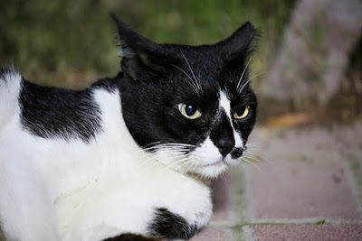
I
think Scott was just plain jealous about the penguins. I don’t blame him. They
live in a protected
 |
| African Penguin. A species endemic to South Africa. |
environment. Protected by the government as well as nature.
Boulders Beach has big boulders (no surprises there) that stand up to nasty
waves and break them down to gentle swells. Not that penguins are afraid of
rough seas. They might walk like Charlie Chaplin on land. But in the sea, they
are like little Michael Phelps in tuxedos. It’s a safe environment to live,
breed, and sunbathe. Plus, they don’t have to pay rent or taxes. Heck! If I was
a little shorter, I’d have made a bespoke penguin suit and lived there quietly.
Or, maybe performed a tap dance to liven up things. I can just imagine the
Dutch squealing. ‘Oh look, a dancing peengooin’.
And then I’d have been christened Happy Feet.
 |
| The staring contest is a regular event here. |
As
we walked further down the walkway, I spotted my first penguin. Actually, it
spotted me first and waddled under the walkway. And then as I walked further
on, I realized that the penguin was walking right below me. When I stopped, it
stopped. When I resumed walking, it also started walking. I was fascinated.
When we reached the viewing point, I saw dozens of penguins staring back
patiently at the gawking tourists clicking away with cameras of all shapes and
sizes. It was a pretty funny sight actually. It was a staring game that the
penguins always won.
After
Boulders Beach, the road started climbing upwards leaving the heaving sea far
below while clinging to the side of a lofty mountain range. Scott also got into
Grand Theft Auto mode and I started getting a bit nervous. But within 20
minutes or so, we were inside the Cape Point National Park.
 |
| There's a different kind of energy at Cape Point. |
Apparently,
it was a pretty stormy day when a Portuguese explorer named Bartolomeau Dias,
set his sights upon the Cape of Good Hope. However, it wasn’t known as the Cape
of Good Hope then. It was left to the limited imagination of Bartolomeau to
name it as Cabo das Tormentas or the Cape of Storms. I guess a young sailor who
was entrusted with the responsibility of jotting down names of the places would
have rushed to Bartolomeau’s side the moment they saw the cape. He must have
been agog with excitement and like most young people, impatient to carry out
his duties. He must have pestered Bartolomeau to name the cape. Bartolomeau,
tired and hungry after battling the waves, must have glared at his young aide
and might have muttered something to the effect of ‘Well, my lad, didn’t you notice that it was a
bit stormy today. And I can bet you my last guinea that sure it’ll be stormy
tomorrow also. And the day after too. So, let’s name it – Cabo das Tormentas.
Now put that down in triplicate and get my bath ready.’
John
II, also from Portugal, later renamed it as the Cape of Good Hope. Named
because, all of a
 |
| Cape of Good Hope. As seen from Cape Point lighthouse. |
sudden, there was a route and consequently, access to the
fabulous riches of the Orient. See, all these explorers knew they had to take a
left somewhere from the continent of Africa to reach India. Point is, they
didn’t have any reference. With the Cape of Good Hope landmark, the directions
became very easy.
‘Just take a left from Cape of Good Hope and keep on going east. Mind the scurvy though.
Take lots of reading material. I’d recommend the
Ulysses. Good to swat those pesky flies. By the way, let me know when you
establish a colony.’
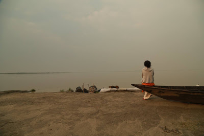
I
heard at least three people exclaim at the colour of the two oceans. On a day
when the wind doesn’t threaten to sweep one off from the Cape Point lighthouse
built in 1859, one can apparently spot the different shades of the Indian and
Atlantic oceans. I tried hard. But couldn’t really differentiate between the
two oceans. Later I read that the oceans merge all along the coast and not
abruptly at Cape Point. Another fact that often gets buried under the
excitement of standing at the southernmost point of the African continent is
that it is not really the southernmost point. Cape Aguilhas, located 155km
southeast of Cape Point is actually the southernmost point.
 |
| Looking out for the ghost ship - The Flying Dutchman. |
As
we know when two massive corporations merge, things shake up a bit. It’s
similar when two oceans meet. Obviously there’s going to be some churn. Where
only the fittest survive. The rough seas around the cape have sent several
ships to the bottom. Most famous of them is the Flying Dutchman, a Dutch
warship. The ship battled long against the stormy seas but ultimately perished.
Regular ghostly sightings of the Flying Dutchman in full sail were officially
reported till the turn of the 19th century. Even now, when the wind howls for
days on end, the clouds darken and the waves rear high, people try to spot the
Flying Dutchman cutting through the waves. This is despite the fact that it’s
supposed to be a bad omen to spot it. I guess some do like to live their lives
a bit dangerously.
I
didn’t see the Flying Dutchman. It wasn’t that kind of day. Thankfully. But it
was difficult not to feel a different kind of energy while looking across the
Atlantic from the cliffs overlooking the Cape of Good Hope. There’s a funicular
that takes people to the Cape Point lighthouse. Manned by staff that dole out
funny instructions with a straight face. The name of the funicular – The Flying
Dutchman.
I thought the high point of the day was over
as we headed back to Cape Town by the other part of
 |
| The magnificent Noordhoek beach. |
the circular route. But
without hurting sentiments of the folks that live on the Kalk Bay-Simons
Town-False Bay-Boulders Beach route or the M4, I’d like to say that this stretch
of coastline (Noordhoek-Chapman’s Peak-Hout Bay-Llandudno-Camps Bay route) was
even better. The towns and villages were prettier. The beaches were grander. But the
piece de resistance was the drive to Chapman's Peak or ‘Chappies’ as it is fondly referred to. A magnificent winding road carved
out of steep cliff faces. A road that is often seen in TV commercials that
features flashy cars. A road that has starred in many Hollywood productions.
 |
| The drive to Chapman's Peak. Unforgettable. |
Scott
used to race up and down this road when it was really narrow and the chances of
overshooting a bend and plummeting down to the Atlantic was greater. But then
the government had to play party-pooper. It broadened the road, strung massive iron
nets on the rocks that often threatened to crush puny cars (incidents did
occur, hence the nets) and basically killed the spirit of the road. ‘Nowadays,
cyclists race this road.’ Scott muttered with utter disdain. ‘Whenever I cross
them in their shiny bicycles, safety helmets and tight shorts, I feel a deep
pain inside.’ He then made a quick swerving gesture with the steering wheel.
I fear one day some cyclist will end up in a
lot of pain. Just like a penguin.
 |
| Sunset from Chapman's Peak overlooking Hout Bay. |
We made it to Chapman’s Peak just in time for
a sunset in technicolour. As I soaked in a glorious palette of orange
stretching across the Atlantic, I came to a conclusion. I think I know now where I want to settle
down forever.
 The tale got over 18000 ‘hearts’ on Instagram and received over 530 comments.